Jan Bartek - AncientPages.com - Experts have uncovered information concealed for two centuries in a navigational chart created for 18th-century seafarers navigating the Red Sea and Gulf of Aden.
The beautiful paper scroll demonstrates that seafaring communities in the region developed an effective navigation system that supported trade among India, Arabia, and the Horn of Africa before the adoption of instrument-based navigation.
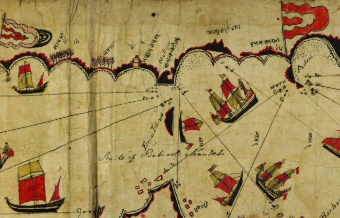
The Indian Kachchhi/Gujarati document has been part of the Royal Geographical Society’s collection for 189 years. Credit: Royal Geographical Society
This Indian Kachchhi/Gujarati document has been in the Royal Geographical Society’s collection for 189 years and is among the most detailed surviving indigenous navigational charts from the Indian Ocean tradition.
Recent research shows it served as an effective aide-memoire, capturing the detailed knowledge of sailors from modern Gujarat. It offers insight into indigenous navigational practices across the western Indian Ocean.
For the first time, researchers have identified and interpreted place names and astronomical data on the chart, establishing latitude, providing sailing directions, and demonstrating detailed local knowledge. The chart was intended for more than just long-distance transit to major Red Sea ports.
The chart, decorated with images of ships and religious buildings, dates from the late 18th or early 19th century. Alexander Burnes acquired it in 1835 from an unnamed sea captain in Kachch and donated it to the Royal Geographical Society. However, neither he nor later scholars were able to translate and analyze the map as thoroughly as the current study.
The approximately 66 Devanagari place names on the chart have never been fully transcribed or identified. Most European scholars who reviewed the chart incorrectly claimed it lacked latitude or longitude information. They also considered its depiction of the Red Sea and Gulf of Aden as a limitation, when in fact this feature enhances the chart’s portability.
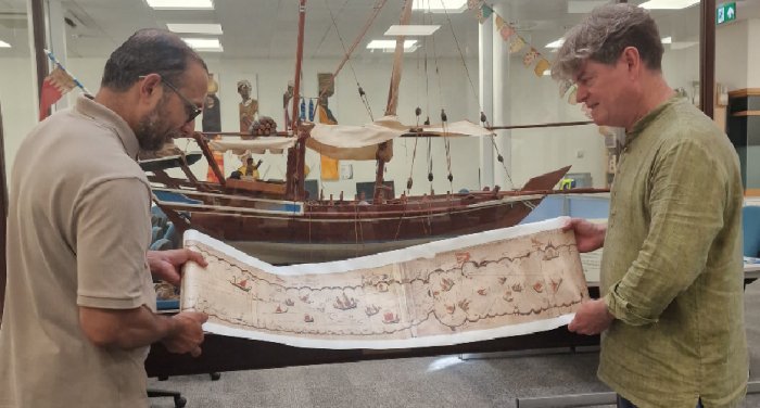
Credit: University of Exeter
Experts have created a chart projection that displays its information spatially, similar to modern maps.
The cartographer depicts more than 180 islands, as well as reefs, landmarks, religious buildings, and flags.
Alexander Burnes (1805–1841) acquired the chart while serving as a lieutenant in the East India Company and assistant to the British Resident in Kachchh. He had already gained recognition for his 1832 expedition across Central Asia, which led to a best-selling book, honors from London learned societies including the RGS, and an audience with King William IV.
He stated it would “form a specimen of naval surveying … unequaled in any of the cabinets of Europe” and believed it was a working document used on board ship. However, he did not realize it was a practical navigational chart.
The chart was previously interpreted in 1947, 1987, 2002, 2012, and 2022, but scholars overlooked its navigational features. About half of the Devanagari toponyms remained unidentified or imprecisely located.
Researchers now believe they have identified coordinates for all 66 toponyms and improved the transcriptions of the Devanagari script.
They found that the chart’s 29 rhumb lines serve three main purposes: establishing the principal trend of a coastline, indicating directions of travel across open water, and, in two cases, showing safe passage into and out of port.
Professor John Cooper, from the University of Exeter’s Institute of Arab and Islamic Studies, who led the research, said: “Today we are accustomed to maps and charts that project space mathematically and to scale, making regions of the world visually familiar and accessible in a specific way. Although this chart may not appear accurate by modern standards, it enabled experienced seafarers with knowledge of stellar navigation to traverse some of the world’s most challenging waters. All essential information was contained in a portable scroll just 25cm wide.”
“This is a rich and effective navigational reference: its stellar information allowed sailors to determine latitude and set sailing directions; its place names and topographical details enabled precise positioning; its depiction of religious buildings suggests the navigator’s Muslim faith; and its flags indicate centers of political and fiscal activity.”
“It was intended for users with specific local navigational knowledge. While comprehensive, the information would not suffice for those unfamiliar with regional seafaring traditions. For experienced navigators, it served as a practical reference at sea, supporting memory. The scroll format allowed partial opening to display only the relevant section, with the remainder rolled away. It was easy to store and handle on board.”
See also: More Archaeology News
Dr Katherine Parker, the Royal Geographical Society’s Cartographic Collections Manager, said: “Re-examining our Collections is an ongoing process that allows researchers to apply new methods, technologies, and perspectives, revealing the meanings and utility these remarkable artifacts held for their creators centuries ago. We have been delighted to work with the team to highlight the navigational, geographical, and cultural value of this chart, as well as the cartographic skill and knowledge of its creators.”
Source: University of Exeter
Written by Jan Bartek - AncientPages.com Staff Writer