
LIDAR Technology Reveals Lost Bronze Age Forts In Devon
Conny Waters - AncientPages.com - Because of its ability to capture extraordinarily accurate, high-resolution, 3D data LIDAR (Light Detection and Ranging) has become an appreciated tool among archaeologists. LIDAR has been used to find lost ancient cities, pyramids in the South American jungle, and other structures that are obscured by dense and protected vegetation.

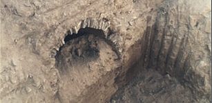
The 100ft wide circle on a hilltop above Berry Pomeroy. Credit: Darren Murray
Like many other people in the UK, Darren Murray, an amateur archaeologist and photographer in Brixham has spent plenty of time in lockdown, but he uses his time wisely.
Combining his knowledge of ancient history, archaeology, and a new type of laser light technology, Darren Murray started looking for hidden ancient structures and he has discovered something quite extraordinary.
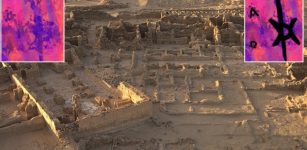
On the outskirts of Paignton, there is something hidden beneath the ground. The structure is revealed in 3D the shape of the ground beneath the trees.
Darren Murray “used photography filters which made previously hard to spot details leap out. His photographs reveal in detail the exciting 100ft wide structures. He believes they are clear pictures of uni-vellate single ring fortresses, possibly built by the Dumnonii tribe which inhabited Devon and Cornwall.
See also:
LIDAR Technology Reveals Secrets Of Ancient Maya Civilization
Will Lidar Survey Help To Unravel Mystery Of Ancient Staircase In Cambodia?
Both the South Devon hill sites - one near Paignton and one at Berry Pomeroy - are crowned with distinctive tree clumps and the lost forts are buried beneath, Darren says. He believes that over the last millennium farmers were not able to plough the land because of the rocky remains of the forts below,” Devon Live reports.
“I seem to have discovered two lost Bronze Age ring forts in Torbay.
I've messaged the Exeter Museum Finds Liaison Officer about it and they obviously can't do anything at the moment.
But the FLO Exeter emailed yesterday and said they were brilliant images and they are now with the county archaeologist. The pictures clearly show the forts using digital Terrain Modelling LIDAR data.

The hill fort near Paignton. Credit: Darren Murray
It works by shooting lasers and strips away all the trees so that you can clearly see the contours of the land,” Darren said.
Darren also explained archaeology and photography are his hobbies and he has always been curious about one of these hilltops.
He compared his finds to pictures of the well-known Noss Iron Age Hill Fort near Dartmouth
"I love this stuff and in recent months I have been looking at the Noss site on the River Dart which was a lookout point.
See also: More Archaeology News
One of the hill forts has a bump in the middle which could have been a barrow burial mound.
Both of them are on the limestone plateau from Churston to Marldon. The area is well known for Bronze Age burials," Darren said.
Written by Conny Waters - AncientPages.com Staff Writer
More From Ancient Pages
-
 Wrecks of ancient ships found in Malaysia’s Sungai Batu ancient site
-
 First Animals On Earth Could Have Evolved Much Earlier Than The Oldest Fossils Suggest
-
 Mystery Greek tomb was dedicated to companion of Alexander – experts say
-
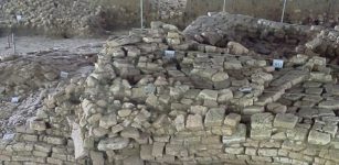
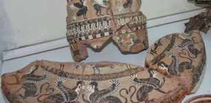 One Of A Kind 2,500-Year-Old Ritual Wash Basin Painted With Mythological Figures Discovered In The Ancient City Of Klazomenai
-
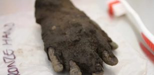 Rare Bronze Hand Found At Roman Vindolanda
-
 2000-Year-Old Tomb Discovered In Northwestern China
-
 Understanding The Green Sahara’s Collapse
-
 DNA Study Suggests Human Language Emerged 135,000 Years Ago
-
 Remarkable Discovery Of Ancient Drilled Bear Teeth In Kansas – How Did They End Up On The Great Plains?
-
 Previously Unknown Early Christian Church Unearthed In Ancient City Of Artaxata
-
 When And Why Negev Highlands’ Agricultural Settlement Was Abandoned? – Researchers Have Answers
-
 Rare Roman Brooch And A Miniature Sword – Unearthed
-
 On This Day In History: Favorite Ship Of King Henry VIII ‘Mary Rose’ Sank – On July 19, 1545
-
 Lost Kingdom Of Idu Hidden Beneath A Mound And Its Seven Unknown Kings
-
 El Volcán: Mysterious Volcano-Shaped Pyramid With Never Revealed Secrets In Peru
-
 Unusual Archaeological Object Reveals Traces Of Prehistoric Settlements Mikołajki
-
 Rare Medieval Tattoo Depicting A Christogram Unearthed In Ghazali, Sudan
-
 When Did Humans Start Using Roads And What Civilization Built The First Paved Roads?
-
 Legendary Lost Island Of Gold Of The Mysteriously Vanished Srivijaya Civilization Found Underwater
-
 Examination Of Six 19th-Century Remarkable Dahomean Swords Crafted From Locally Smelted Iron