
Strangest Maps Ever Created – You Have Never Seen Our World Like This!
Conny Waters - AncientPages.com - In ancient times, people saw the world in a very different way. This collection of maps must be one of the strangest representations of world depictions ever created.
Some of these maps are fantasy. As you can see, the shapes of the countries and continents are odd representations of figures or animals. Other maps depict what our ancestors believed to be Biblical Lands.
“Legends of strange human beings have a long history, as do their depictions on maps. Many of these representations were derived from the descriptions given in the Natural History of the World by the elder Pliny (AD 23-79) and first printed in Latin in 1469. Pliny’s ideas were absorbed by most geographers of the 16th century and were particularly well illustrated in the successive editions of Ptolemy’s maps published by Sebastian Munster from 1540 onwards.
On the Ptolemaic map of Asia, a number of strange beings are placed in Scythia or part of Northern Asia.
At the top of the map, Munster shows the Anthropophagi, who feed on men’s flesh and live near the North Pole.
In the margins he depicts those humans described by Pliny in Book 7:
“In India there is a kind of men with heads like dogs…who in lieu of speech use to bark.
Likewise there is a kind of people named monoscelli that have but one leg apiece.
In the hottest season of Summer, they lie along their backs and defend themselves with their foot against the Sunnes heat.”
Then of course we have the legendary Garden of Eden. For over 1500 years the existence of the Garden of Eden was an unquestionable fact for most Christian believers. Its location varied, but in the early Middle Ages, it was generally thought to be at the eastern extremity of the world, while later it was placed in the area of Mesopotamia.

Islandia. From the Theatrum Orbis Terrarum of Abraham Ortelius. Antwerp, c. 1585. Credit: Yale University
Early mapmakers often recorded on their maps and charts the presence of fabulous beasts, many of which reveal themselves as identifiable species made grotesque by the embroidered tales of sailors and travelers. Of the many maps depicting sea monsters, the Carta Marina by Olaus Magnus was the most influential. First printed in 1539, it showed the area of the North Sea filled with dangerous maritime creatures. Versions of Olaus Magnus’s monsters populated the seas on charts until the mid-18th century.
Ortelius copied many of these monsters for his map of Iceland, published in editions of his Theatrum Orbis Terrarum. Iceland is shown at a large scale, with its fjords, glaciers, and mountains, including an erupting volcano, Mt. Hekla. Polar bears on icebergs can be seen at the top right, while the ocean contains probably the most fantastic collection of sea monsters to be seen on one engraving.

Asia Secunda Pars Terrae in Forma Pegasir. Die Gantze Welt in ein Kleberblat. Heinrich Bunting, c. 1590. Credit: Yale University
Among the earliest cartographic oddities are the famous maps from Heinrick Bunting’s Itinerarium Sacra Scripturae, or Travels According to the Scriptures, first published in 1581. A description of Biblical lands, it was a popular book that was reprinted many times. In addition to correct maps of the Holy Land, it also contained three maps of pure fantasy: the world in the form of a clover leaf, Europe as a robed female figure, and Asia as Pegasus the mythical winged horse.

Credit: Yale University
The horse is drawn fairly realistically so that the shape of Asia has to be adjusted; the Caspian Sea lies horizontally between the wings and the saddle, and modern India is the off hind leg. The Pegasus map can be found in a number of different editions in both woodcut (as displayed here) and more rare copperplate versions.
In Bunting’s map of the world as a clover leaf, representing the Trinity, each of the three continents of the Old World forms a section, with Jerusalem in a circle in the center. England and Scandinavia appear separately at the northern edge of the map, and the new continent of America can be seen in the lower left corner.

Credit: Yale University
It has been suggested that the cloverleaf design represents not only the Trinity but the arms of Bunting’s native city of Hanover.
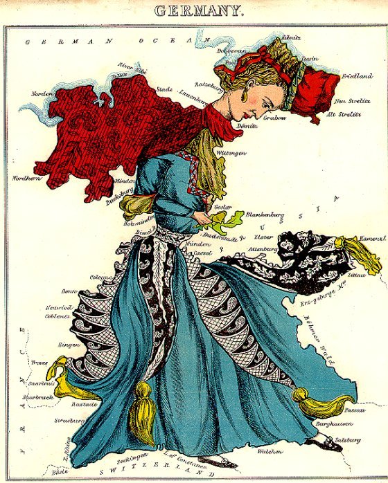
These maps are from Geographical Fun, or Humorous Outlines of Various Countries, published by Hodder and Stoughton in 1869. The author, William Harvey writing under the pseudonym Aleph, created a series of twelve maps showing various countries as curious people in the great tradition of English caricaturists. The idea behind the maps was taken from sketches drawn by a fifteen-year-old girl wishing to amuse her sick brother confined to bed.

Harvey states in the introduction: “It is believed that illustrations of Geography may be rendered educational, and proof of service to young scholars who commonly think Globes and Maps but wearisome aids to knowledge.” The maps and rhymes were thus designed to amuse children and to teach some basic geographical concepts, rather than as political satires.
These maps are part of the Yale University Map Collection.
Written by Conny Waters - AncientPages.com Staff Writer
More From Ancient Pages
-
 Sweden’s Blue Maiden ‘Blåkulla’ Island – Mythical Place With Dark Secrets Of Witches And Wizardry
-
 Secrets Of Viking Crystal Sunstones Revealed By Modern Science
-
 What Ancient Civilization Discovered Metallurgy?
-
 Ancient Egyptian Visual Depiction Of The Milky Way Discovered
-
 Previously Unknown Monumental Etruscan Temple Found Near The Tempio Grande, Vulci, Latium, Italy
-
 Roman Treasure Hoard Found In Thetford Forest, East Anglia – Was Pagan Until 5th Century
-
 The Black Obelisk Of Shalmaneser III – Great Assyrian Ruler
-
 Ancient Mystery Of The Le Câtillon Hoard – The Largest Celtic Iron Age Hoard Ever Unearthed
-
 Secrets Of 160,000 Ancient Texts Kept In The Abbey Library Of St. Gall May Soon Be Unlocked By AI
-
 Ancient Secrets Of Mistletoe – Sacred Celtic Plant With Magical Powers
-
 Neanderthals Lived Much Longer In Gipuzkoa Than Previously Thought
-
 Eridu: Pre-Flood City That Belonged To Enki, God Of Creation, Intelligence, Wisdom And Magic
-
 10 Remarkable Advanced Ancient Technologies Ahead Of Their Times
-
 Long-Lost Ancient Tomb Of ‘China’s Shakespeare’ Finally Found
-
 War God Ares Was Brutal, Merciless And Disliked By Greeks But Popular In His Love Affairs
-
 Focus On Turkana Boy: Modern Human Body Evolved More Recently Than Once Believed
-
 Sumerian King List – Ancient Record Of Kingship That Has Long Been Of Great Interest
-
 Confucius: Philosopher, Educationist And Great Intellect With A Noble Morality
-
 Significance Of Secret And Powerful Number 108 That Has Accompanied Humankind For Thousands Of Years
-
 Ancient Humans Were So Good At Surviving The Last Ice Age They Didn’t Have To Migrate Like Other Species – New Study