
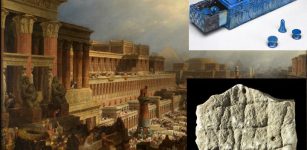
The Vinland Map Is A Fake – New Evidence Uncovered By Scientists
Jan Bartek - AncientPages.com - The Vinland Map, once hailed as the earliest depiction of the New World, is awash in 20th-century ink. A team of conservators and conservation scientists at Yale has found compelling new evidence for this conclusion through the most thorough analysis yet performed on the infamous parchment map.
Acquired by Yale in the mid-1960s, the purported 15th-century map depicts a pre-Columbian “Vinlanda Insula,” a section of North America’s coastline southwest of Greenland. While earlier studies had detected evidence of modern inks at various points on the map, the new Yale analysis examined the entire document’s elemental composition using state-of-the-art tools and techniques that were previously unavailable.
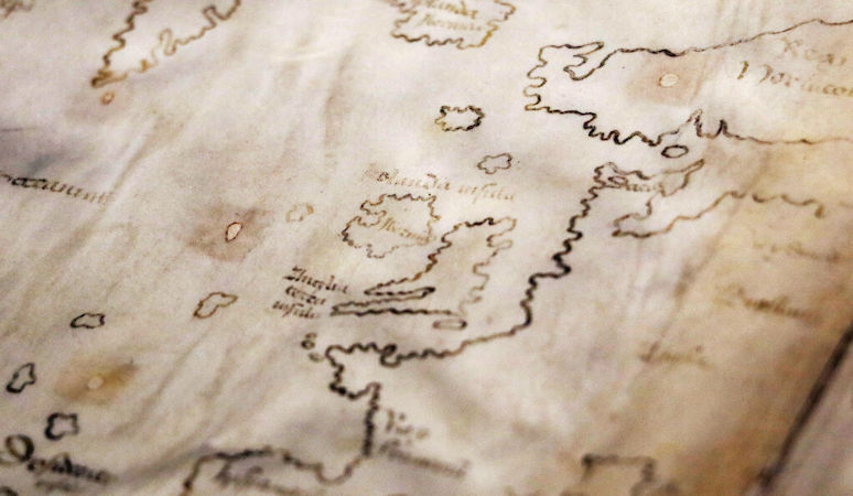
The Vinland Map, which purports to be a 15th-century map with a pre-Columbian depiction of the North American Coast, was drawn with modern inks, suggests a new analysis by Yale scientists and conservators. Credit: Yale University
The analysis revealed that a titanium compound used in inks first produced in the 1920s pervades the map’s lines and text.
“The Vinland Map is a fake,” said Raymond Clemens, curator of early books and manuscripts at Yale’s Beinecke Rare Book & Manuscript Library, which houses the map. “There is no reasonable doubt here. This new analysis should put the matter to rest.”
The new study also uncovered evidence that the map deception was intentional. A Latin inscription on its back, possibly a bookbinder’s note guiding the assembly of the Speculum Historiale — an authentic medieval volume and the likely source of the map’s calfskin parchment — is overwritten with modern ink to appear like instructions for binding the map within the genuine 15th-century manuscript.
“The altered inscription certainly seems like an attempt to make people believe the map was created at the same time as the Speculum Historiale,” Clemens said. “It’s powerful evidence that this is a forgery, not an innocent creation by a third party that was co-opted by someone else, although it doesn’t tell us who perpetrated the deception.”
Yale created a sensation in 1965 when it announced the Vinland Map’s existence and published a scholarly book about it by Yale librarians and curators at the British Museum in London. Its discovery seemed to demonstrate that Norsemen were the first Europeans to reach the New World, landing in the Americas well before Columbus’ first voyage. (Archeological discoveries at L’Anse aux Meadows in Newfoundland during the 1960s confirmed that the Vikings had built settlements in the Americas long before Columbus sailed.)
From the beginning, however, scholars began to question the map’s authenticity. And over time an overwhelming consensus has emerged that it is indeed a 20th-century forgery.
An In-House Study
The map has been subjected to multiple analyses over the years. A 1973 study by the McCrone Research Institute in Chicago found that its ink contains anatase, a form of titanium dioxide first used commercially in the 1920s. The most recent examination of the full map prior to the new Yale study was conducted by Danish scientists, who in 2004 measured its color, thickness, flexibility, and transparency while assessing damage to its parchment.
This latest analysis provides the clearest evidence yet that the map is a fraud.
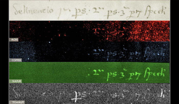
An inscription on the back of the map (top), possibly a bookbinder’s note for assembling the medieval volume with which it was originally bound, was overwritten in an apparent attempt to deceive. The bottom image shows the presence of titanium in the ink, which strongly suggests it is of modern origin, while the preceding three false-color images highlight elements that are consistent with medieval iron gall ink.
The examination paired Yale University Library conservators Marie-France Lemay and Paula Zyats — experts in the materials and physical structures of early books and manuscripts — with a team of scientists at the Institute for the Preservation of Cultural Heritage on Yale’s West Campus. That team included Anikó Bezur, the Wallace S. Wilson Director of the Technical Studies Laboratory; Richard Hark, a conservation scientist who works with the Beinecke Library’s collections; and Pablo Londero, now senior conservation scientist at Louvre Abu Dhabi.
Unlike the previous studies, the Yale team had unfettered access to the map and its accompanying manuscripts for as long as their work required. They also had the time and space to consult closely with Clemens and each other on the specific questions that they wanted to answer, said Bezur.
It also allowed the researchers for the first time to systematically examine the map alongside the two medieval texts with which it was originally bound. One is the Speculum Historiale, a popular four-volume medieval encyclopedia by Vincent de Beauvais. Yale possesses a copy of a portion of the work’s third volume, which is dated to the Council of Basel, a general council of the Roman Catholic Church that took place between 1431 and 1449 in Switzerland. The other manuscript, the Hystoria Tartorum, or Tartar Relation, is an account of a journey by two Polish clerics into the lands of Genghis Khan in mid-1200s.
“Studying the three objects together is important to learning their full story,” said Zyats, head of rare books conservation for the Yale Library.
Matching wormhole patterns indicated that the map was originally located at the front of the Speculum Historiale and was likely drawn on one of the volume’s end sheets, Zyats said. But when the map arrived at Yale, it was bound inside the slim copy of the Tartar Relation, which had a modern binding. The university subsequently acquired the Speculum Historiale.
Radiocarbon dating performed on both manuscripts in 2018 showed that their parchment and paper date approximately from 1400 to 1460, which correlates with prior carbon-dating done on the map. A watermark on a paper leaf of the Speculum Historiale is traceable to a papermill that operated in Basel during the 1440s, corroborating the theory that the two manuscripts were made during the Council of Basel, Zyats explained. Also, the text in both manuscripts is written in a similar style, likely by the same scribe.
The recent discovery of a 14th-century copy of the complete Speculum Historiale in Lucerne, Switzerland that had a copy of the Tartar Relation bound in its last volume shows there is historical precedent for combining the two manuscripts, Zyats said. (The Lucerne copy of the Tartar Relation joins Yale’s copy as the only two known to exist.)
‘The Big Picture’
About the size of a placemat, the Vinland Map lacks the elaborate ornamentation of other medieval maps, such as the Beinecke Library’s collection of portolan nautical charts. Patched wormholes dot its parchment. Much of its ink appears faded.
The members of the Yale team focused their attention on the ink used in the map. Using X-ray fluorescence spectroscopy (XRF), a non-destructive technique, they identified the distribution of elements throughout the map. While scientists for decades have used XRF to study the elemental composition of specific points on an object, Bezur said, only recently have they been able to use it to scan an entire two-dimensional object in a laboratory setting.
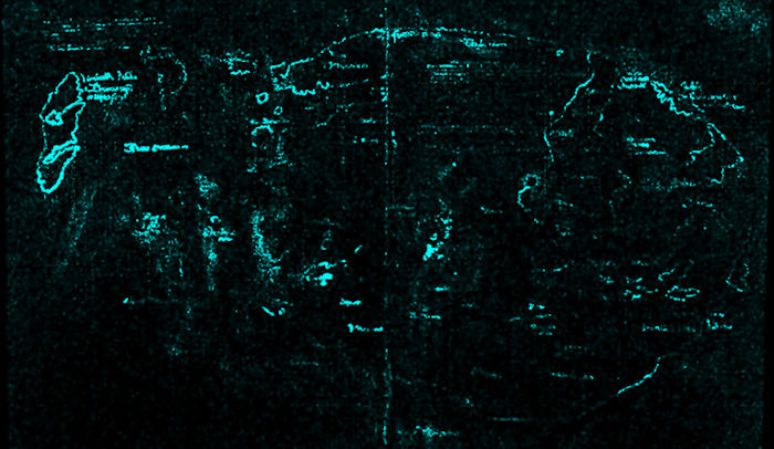
Macro X-ray fluorescence spectroscopy (XRF) revealed the presence of titanium throughout the map’s lines and text. Previous analyses showed titanium in specific points on the map. This new study demonstrated that it pervades the entire map.
“With macro-XRF, we can generate a one-to-one scale elemental map of the map,” Bezur said. “That’s huge because it allows us to share a full dataset of the entire map. We’re not picking and choosing individual points. We’re offering the big picture.”
Medieval scribes typically wrote with iron gall ink, which is composed of iron sulphate, powdered gall nuts, and a binder (the first two are primary elemental ingredients of iron gall ink, and the third is often present as an impurity). The XRF analysis of the Vinland Map showed little to no iron, sulfur, or copper. Instead, the scan revealed the presence of titanium throughout the map’s ink.
A scan of Vinlanda Insula, the portion of North American coastline that made the map famous, revealed high levels of titanium and smaller amounts of barium — a key revelation as the earliest commercially produced titanium-white pigments in the 1920s contained titanium dioxide and barium sulfate.
Having mapped the distribution of elements, the team used Raman microscopy, a type of molecular microscopy, to confirm that the titanium dioxide in the map’s ink is in the form of anatase. While an earlier study had utilized Raman microscopy in analyzing nine points on the map, the new study found that anatase is broadly distributed on the document.
With help from Marcie Wiggins, assistant conservation scientist at IPCH, the team analyzed the inks in 50 manuscript fragments in the Beinecke Library’s collection that were produced in Central Europe during the 15th century, approximately when the Vinland Map was supposedly drawn. They found that the fragments contain far lower levels of titanium than the map and much higher levels of iron.
To confirm that the map’s ink was of modern origin, and that the anatase wasn’t simply unique and naturally occurring, the team performed field emission scanning electron microscopy (FE-SEM) on samples from the altered text of the Tartar Relation and the map. This process yielded highly magnified images of its ink’s components, which showed that the anatase particles closely resemble those found in pigment that was commercially produced in Norway in 1923. Nothing suggested that the anatase was naturally sourced, Hark said.
Having determined that the ink’s composition was consistent with an early form of commercially available titanium white, the team spotted evidence that the map is a deliberate forgery.
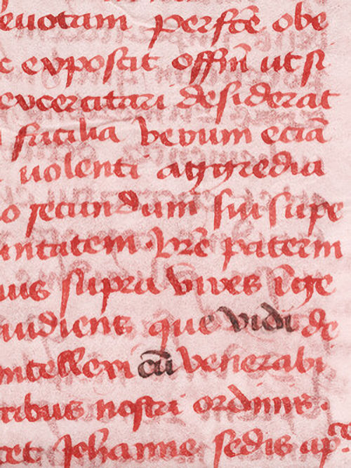
Infrared light exposed altered text in the Tartar Relation, the authentic medieval manuscript that the map was bound with when it arrived at Yale. Analysis showed the altered text is composed of modern ink.
The original Latin inscription on the reverse side of the map, written in iron gall ink, translates to “second part of the third part of the Speculum.” It could be a bookbinder’s note on assembling the Speculum Historiale, which is a massive work containing 32 sections that are usually bound in four volumes. But in this case, the inscription was overwritten in a titanium-containing ink to roughly translate to “drawing first-part, second-part of the third part of the Speculum.” Yale’s copy of the Speculum Historiale consists of books 21 to 24, which is the second half of the encyclopedia’s third volume, Hark explained.
“I think that constitutes pretty strong evidence of a motive to deceive — to make the map look like something it is not,” Hark said.
‘A Historical Object’
The team members plan to describe their work and findings in scholarly articles. For his part, Clemens hopes to publish an article in a leading cartography journal that definitively shows the map for what it is: a fake.
“Objects like the Vinland Map soak up a lot of intellectual air space,” Clemens said. “We don’t want this to continue to be a controversy. There are so many fun and fascinating things that we ought to be examining that can actually tell us something about exploration and travel in the medieval world.”
The analysis demonstrates the value of the expertise and resources provided by the Yale Library’s Center for Preservation and Conservation and IPCH, which enable the in-house analysis of materials in the university’s collections and those being considered for acquisition, he said.
See also: More Archaeology News
Hark, Lemay, and Wiggins are currently working on a project with the Morgan Library in Manhattan to analyze the Visconti Tarot, lavishly hand-painted tarot cards decorated with gold and silver foil that were created in Italy in the mid-15th century. They are among the earliest sets of tarot cards known to exist. The Beinecke and Morgan both house decks of the cards, whose authenticity is not in doubt. The researchers hope to learn more about how they were made.
As for the Vinland Map, it will remain at the Beinecke with the accompanying manuscripts, Clemens said.
“The map has become a historical object in and of itself,” he said. “It’s a great example of a forgery that had an international impact and it’s an integral part of the Speculum Historiale, which is a genuinely fascinating manuscript.”

Written by Jan Bartek - AncientPages.com Staff Writer
More From Ancient Pages
-
 Roman glass-making furnaces discovered in Egypt’s Delta
-
 On This Day In History: Vlad III Dracula Regained Throne Of Wallachia For The Third Time – On Nov 26, 1476
-
 Look Inside The Magnificent Grotto Of Diana At Villa d’Este That Reopens After 50 Years
-
 For The Ancient Maya, Cracked Mirrors Were A Path To The World Beyond
-
 Rare 2,500-Year-Old Scythian Bone Sceptre Discovered In Bulgaria
-
 Mysterious Viking Burial Site Of Three Women In Norway Reveals Its Secrets
-
 Mysterious Tiny Pre-Viking Gold Foil Figures Baffle Scientists
-
 Study Reveals Average Age That Women And Men Had Children Over Past 250,000 Years
-
 Unearthing Vadnagar And The Search For Hueng Tsang’s 10 Monasteries
-
 Statue Of Greek Health Goddess Hygieia – Unearthed
-
 Early Christian Landmark – Re-Evaluation Of Its Architecture And Practices
-
 4,500-Year-Old Board Games And Game Pieces Unearthed At Gath
-
 Shangshan Culture Drank Ancient Rice Beer 10,000 Years Ago – Archaeological Evidence Found In China
-
 88 Ice Age Human Footprints In Utah Desert Shed New Light On Ancient Americans
-
 Dargan Shelter, Blue Mountains – Australia’s Oldest Ice Age Cave Was Occupied For Thousands Of Years
-
 Mythical Shield-Maidens Did Exist – Evidence Of Female Viking Warriors Discovered
-
 Rare 3,000-Year-Old Jerubbaal Inscription Of Biblical Judge Discovered In Israel
-
 Research Reveals A 3,500-Year History Of Dairy Consumption On The Tibetan Plateau
-
 Silver Needle Dismissed As Trash Was Part Of A Stunning Viking Treasure Found By Farmer On Gotland
-
 12th Century Idol Of Vishnumurthy Unearthed In Abandoned Well Near Udupi, India