
Amazing Prehistoric Forest Submerged Under Water Thousands Of Years Ago Re-Emerges On Welsh Beach
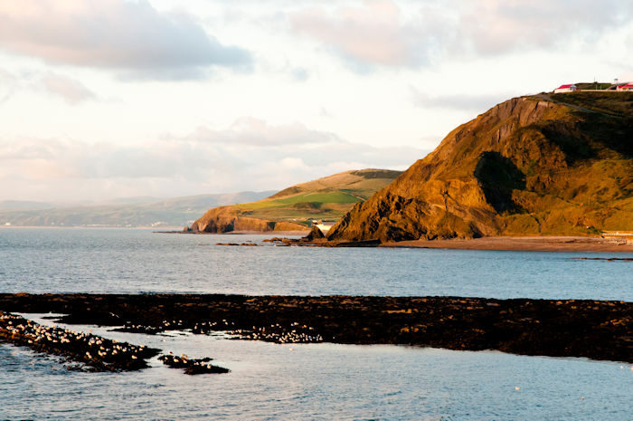
Conny Waters - AncientPages.com - A unique forest submerged under water 6,000 - 8,000 years ago has re-emerged along the Welsh coast. Dozens of tree stumps, trunks, and root systems become visible at low tide at Trearddur Bay.
"Beaches along the Welsh coast have remnants of ancient woodlands, a legacy of rising sea levels brought about by the end of the last Ice Age 20,000 years ago. Over thousands of years, coastal forests were drowned and the outline of Wales was altered as melting ice caused sea waters to rise," Wales Online reported.

Some tree remains have long been seen at Trearddur Bay but it thought more became visible after fierce winter storms altered the beach's profile. Image credit: John Wright
"Evidence of this process can be seen on several beaches on Anglesey, including Lligwy, Lleiniog and Porth Diana. But nowhere are the island’s sunken trees more prominent than on Traeth Trearddur. Photos shared online have been labelled "amazing" and "spooky".
Storms can alter coastal equilibriums and, according to Natural Resources Wales, the fierce winter storms of 2013-14 changed the beach’s profile to reveal more of Trearddur’s long-lost forest, located near the village’s RNLI lifeboat station. Its visibility has ebbed and flowed with subsequent storms but holidaymakers are adamant more trees become visible each time they visit.
The submerged forest is reputed to be 6,000-8,000 years-old. Contrary to common belief, the trees are not petrified (fossilised). Instead they have endured by being waterlogged, much as ancient shipwrecks are preserved in the sea’s anaerobic conditions," North Wales Live reported.
“You should look at them while you can before they disappear,” said Prof John Healy, Professor of forest sciences at Bangor University. “Remains like these are a window into our past.
“They are interesting monuments to the recolonization of Britain by nature after the last Ice Age. They reveal a time when much of Wales was wooded, from the coasts to hillsides below 600 meters; only the tallest peaks remained uncovered.”
As reported by Wales Online, "the great Stone Age forests of Wales in turn fuelled the country’s mines, among them the Great Orme’s huge copper ore operation, Llandudno. The world’s largest Bronze Age mine is estimated to have consumed 400,000-600,000 tonnes of timber over a 1,260-year period.
Coastal trees might have been low-hanging fruit for Bronze Age loggers but the evidence is mixed: at many sites, including Trearddur Bay, trunks can still be found near their stumps, suggesting they succumbed to natural processes rather than intensive harvesting.

Blackened roots can appear as stone but they are not petrified. Image credit: John Wright
Perhaps the most famous of Wales’ prehistoric sunken forest is at Borth, Ceredigion. In the wake of Storm Hannah in 2019, it too re-emerged, so reawakening the legend of the lost kingdom of Cantre’r Gwaelod (the “Sunken Hundred)."
As previously reported on AncientPages.com, there hope to locate the long lost Welsh kingdom has now increased.
"A thorough scientific examination of a Medieval map may confirm a Welsh myth and offer evidence of the long-lost sunken kingdom Cantre'r Gwaelod.
Nicknamed the Welsh Atlantis, the mysterious land was first mentioned in written form in the mid-13th Century, but stories of the unknown kingdom are probably much older.
The Welsh legend of Cantre'r Gwaelod, a lost land sunken below Cardigan Bay, has persisted for almost a millennium, but geographical evidence confirming the story’s authenticity has been missing.
Cardigan Bay - Aberystwyth - Wales. Credit: Adobe Stock - Adwo
This may have changed as two scientists examined a medieval map depicting two islands off the Ceredigion coast. Both these islands are lost to history, and each is about a quarter the size of Anglesey."
Many incredible underwater discoveries may soon come to light because as Dr. Martin Skov, lecturer in marine biology at Bangor University, said Britain’s coastlines are constantly evolving. “If you had the ability to fly like a bird, through time, over this landscape, you would have seen the waxing and the waning of the coastline, with cycles of erosion and expansion on decadal to millennial timescales,” he said.

Several tree trunks are still where they fell thousands of years ago. Image credit: John Wright
Changes in sea level are an obvious driver: the creation of Holy Island, once part of Anglesey’s mainland, is one example. Scientists estimate sea levels have risen on Anglesey by around two meters over the last 4,000 years.
See also: More Archaeology News
Storm surges can remodel coastlines, too, as noted by Giraldus Cambrensis in 1171-2. “The wind blew with such unprecedented violence that the shores of South Wales were completely denuded of sand,” he wrote, Wales Online reports.
“The seashore took on the appearance of a forest grove, cut down at the time of the flood. The tempest raged so fiercely that conger eels and many other fish were driven up on the high rocks.”
Written by Conny Waters - AncientPages.com Staff Writer
More From Ancient Pages
-
 Pharaoh Ramses Was Not One Of History’s Greatest Generals – New Study Ruins His Formidable Reputation
-
 Neanderthals Invented Or Developed Birch Tar Making Technique Independently From Homo sapiens
-
 Discovery Of World’s Oldest Fortresses Reshapes Our Understanding Of Hunter–Gatherers
-
 Why Human Languages Can Be Likened To Branches On A Tree And Help Finding A Single Common Ancestor
-
 On This Day In History: Famous American Author Edgar Allan Poe Found Dying – On Oct 3, 1849
-
 Mysterious Giant Rock Face Discovered On B.C’s Central Coast – Natural Or Man-Made Structure?
-
 Ancient DNA Analysis Shows How The Rise And Fall Of The Roman Empire Shifted Populations In The Balkans
-
 Unknown Ancient Structures Discovered At Machu Picchu By LIDAR
-
 Who Was The Woman Buried With 25 Warrior Monks Of The Order Of Calatrava At The Castle At Zorita De Los Canes, Guadalajara?
-
 Amazing 4,500-Year-Old Egyptian Bead-Net Dress Found In Giza Tomb Restored
-
 Puzzling Runic Inscription Dated To 1050-1500 AD Unearthed In Oslo, Norway
-
 1,000-Year-Old Native American Canoe Recovered From A North Carolina Lake
-
 Never-Before-Seen Colorful Inscriptions And Reliefs At The Esna Temple, Egypt Revealed After Restoration
-
 New Models Shed Light On Life’s Origin
-
 Fascinating Millennia Old Natufian Culture: Funerals With Flowers, Food And Pounding Sound Of Mortars
-
 Fossilized Million-Year-Old Human Skull Of Yunxian Man Excavated In China
-
 Ancient Chaco Was Organized Society Ruled By Women, Study Suggests
-
 Evidence Hominins Were Present In Europe Far Earlier Than Previously Thought
-
 Evidence Of 10,000 Years Of Violent Conflict Among The Hunter-Gatherer Societies In The Atacama Desert
-
 Mysterious Svingerud Stone – World’s Oldest Rune Stone With Enigmatic Inscriptions Investigated By Experts – What Does It Say?