
The 100-Kilometer-Long Stone Highway That Connected Ancient Maya Cities Revealed By LIDAR
Conny Waters - AncientPages.com - More than 8,000 tree-shrouded structures of varying sizes along the sacbe (white road) - with enough total volume to fill approximately 2,900 Olympic swimming pools - have been identified by researchers using lidar technology.
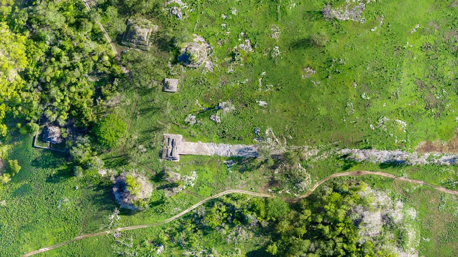 Built at the turn of the 7th century, the white plaster-coated road that began 100 kilometers to the east in Cobá ends at Yaxuná's ancient downtown, in the center of Mexico's Yucatan Peninsula. Photos and drawing courtesy of Traci Ardren and Dominique Meyer/University of Miami
It was the first lidar study of the 100-kilometer stone highway that connected the ancient cities of Cobá and Yaxuná on the Yucatan Peninsula 13 centuries ago.
The study confirms that the road, which measures about 26 feet across, is not a straight line, and it may also shed light on the intentions of Lady K'awiil Ajaw, the warrior queen who - as researchers believe - commissioned the construction of the road at the turn of the 7th century.
Rather, the elevated road veered to incorporate preexisting towns and cities between Cobá, which known for its carved monuments depicting bellicose rulers standing over bound captives, controlled the eastern Yucatan, and Yaxuná—a smaller, older, city in the middle of the peninsula. Yet, the isolated Yaxuná (pronounced Ya-shoo-na) still managed to build a pyramid nearly three times bigger and centuries before Chichén Itzá’s more famous Castillo, about 15 miles away.
“The lidar really allowed us to understand the road in much greater detail. It helped us identify many new towns and cities along the road—new to us, but preexisting the road,” said Traci Ardren, archaeologist and University of Miami professor of anthropology.
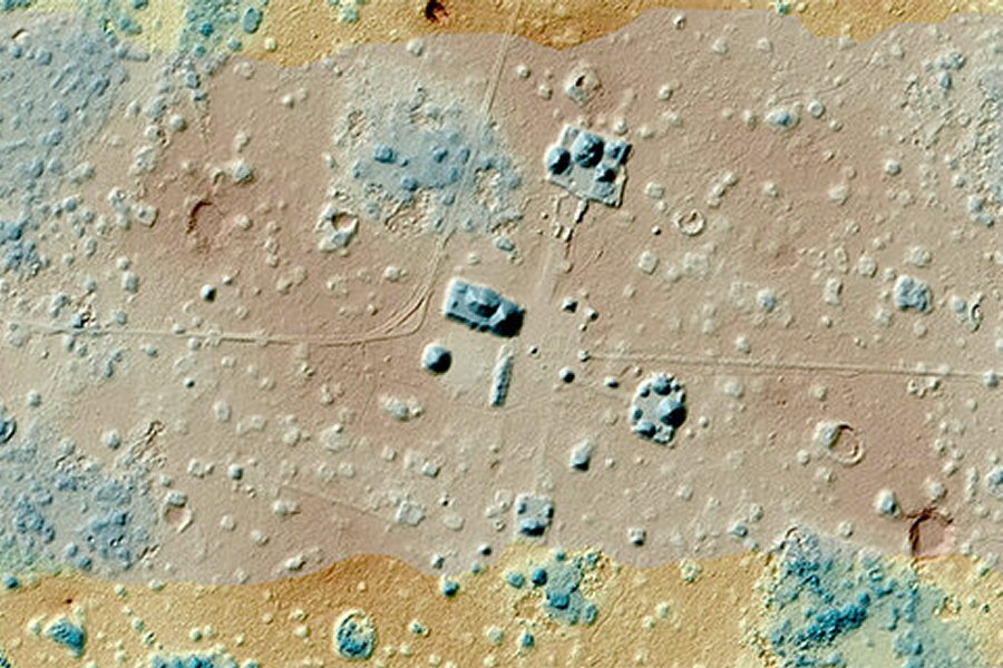 This lidar map of downtown Yaxuna reveals many ancient houses, platforms, palaces and pyramids that are hidden by vegetation. Credit: Photos and drawing courtesy of Traci Ardren and Dominique Meyer/University of Miami
“We also now know the road is not straight, which suggests that it was built to incorporate these preexisting settlements, and that has interesting geo-political implications. This road was not just connecting Cobá and Yaxuná; it connected thousands of people who lived in the intermediary region,” Ardren said.
See also:
Mayan Maize God And Ancient City Of El Mirador
Calakmul Was Powerful Ancient Maya Seat Of The Snake Kingdom
Dzibilchaltún: One Of The Most Ancient Mayan Centers In Northwest Yucatan, Mexico
Xochicalco: Stunning Ruins Of Sacred City Linked To Maya and Aztecs Civilizations
It was partly Yaxuná’s proximity to Chichén Itzá, Mexico’s most famous Maya ruin which flourished after Yaxuná and Cobá waned, that led Ardren and other PIPCY researchers to theorize that K’awiil Ajaw built the road to invade Yaxuná and gain a foothold in the middle of the peninsula. Coba’s ruler for several decades beginning in 640 A.D., she is depicted in stone carvings trampling over her bound captives.
“I personally think the rise of Chichén Itzá and its allies motivated the road,” Ardren said.
“It was built just before 700, at the end of the Classic Period, when Cobá is making a big push to expand. It’s trying to hold on to its power, so with the rise of Chichén Itzá, it needed a stronghold in the center of the peninsula. The road is one of the last-gasp efforts of Cobá to maintain its power. And we believe it may have been one of the accomplishments of K’awiil Ajaw, who is documented as having conducted wars of territorial expansion.”
So far, the researchers have excavated household clusters on the edge of both Cobá and Yaxuná, and they plan to begin the third dig this summer, at a spot informed by the lidar study. It sits between the two ancient Maya cities, on the great, white road that Ardren says would have glowed brightly even in the dark of night.
As she noted, the road was as much an engineering marvel as the monumental pyramids the Maya erected across southern Mexico, Guatemala, northern Belize, and western Honduras. Although built over undulating terrain, the road was flat, with the uneven ground filled in with huge limestone boulders, and the surface coated with bright, white plaster.
See also: More Archaeology News
“All the jungle we see today wasn’t there in the past because the Maya cleared these areas. They needed wood to build their homes. And now that we know the area was densely occupied, we know they needed a lot of wood. Because they also needed it to burn limestone’’—and build the longest road in the Maya world 13 centuries ago. Essentially the same formula the Romans used for concrete in the third century B.C., the plaster was made by burning limestone and adding lime and water to the mixture.
“It would have been a beacon through the dense green of cornfields and fruit trees,” Ardren said.
Written by Conny Waters - AncientPages.com Staff Writer
More From Ancient Pages
-
 4th-Century Roman Coin And Pub-Like Structure With Heating System Excavated In Slovakia
-
 Mysterious Ancient Mass Grave With Roman Skeletons Baffles Archaeologists
-
 Rare And Tiny Ancient Stamps Found In Falster May Show The Way To An Unknown King’s Home
-
 On This Day In History: Samuel F.B. Morse Receives A Patent For His Dot-Dash Telegraphy Signals – On June 20, 1840
-
 Secret Group Searching For Ancient Giants’ Skeletons In NZ Worries Archaeologists
-
 Elongated Skulls: Did Intentional And Intriguing Ancient Tradition Originate In China?
-
 Viklaumadonna Hides A Thousands-Year-Old Secret
-
 Secrets Of The Gods – Why The Papyrus Of Manetho And His Pre-Dynastic King List Upset Egyptologists
-
 Magnificent Solar Alignment Phenomenon In Abu Simbel – The Sun Illuminates The Face Of Pharaoh Ramses II
-
 Mystery Of The East Asian Lineages In Europe 45,000 Years Ago Solved – Population Hub Out Of Africa Holds The Clues
-
 On This Day In History: Last Inca Emperor Atahualpa Captured By Francisco Pizarro – On Nov 16, 1532
-
 Rare Discovery Of More Than 18,000 Inscribed Pot Sherds Document Life In Ancient Egypt
-
 The Americas Were Not Populated Via The Ice-Free Corridor More Than 15,600 Years Ago – New Study Of Boulders Reveals
-
 Arch Of Triumph In 2000-Year-Old City Of Palmyra – Destroyed
-
 Evidence Of Millennia-Old Textile Manufacture And Rare Ancient Eagle-Bone Pin Discovered In Oxfordshire
-
 8,000-Year-Old Nephrite ‘Frog-Like’ Swastika In Bulgaria’s Neolithic Settlement – Unearthed
-
 What Rights Did Viking Women Have?
-
 Is Mysterious Herlaugshaugen The Ship Burial Of Viking King Herlaug?
-
 15,000-Year-Old Petroglyphs Discovered In The Gobi Desert May Be Evidence Ancient Turks Visited Mongolia – Expert Says
-
 On This Day In History: Teotihuacan’s Warlord Siyaj K’ak’ Conquers Tikal – On Jan 16, 378